Are you an avid angler looking for the perfect fishing companion? Look no further than FishAngler - the #1 FREE fishing application. With this app, you’ll have access to prime fishing locations, catch updates nearby, and a real-time fishing forecast - all on-the-go. Say goodbye to outdated maps and unreliable forecasts - FishAngler has got you covered. Let’s take a closer look at the main features of FishAngler. This app offers a variety of high-tech features that will enhance your fishing experiences. With GPS maps decorated with millions of logged catches, you can easily explore new fishing spots. The robust fishing forecast also simplifies determining the best times to fish. Plus, you can record your catches and add real-time weather data for a comprehensive fishing log.
A PEEK INTO THE MAIN FEATURES: FishAngler presents an amalgamation of high-tech features that effortlessly enhance your fishing experiences. Its GPS maps, decorated with millions of logged catches, aid exploration, while the robust fishing forecast simplifies determining the best times to go fishing. Besides, the app allows you to record your catches along with 45+ associated attributes, including real-time weather data. For a social fisher, FishAngler connects you with fellow anglers, facilitating the exchange of fishing tips and, of course, a bit of bragging about your catches.
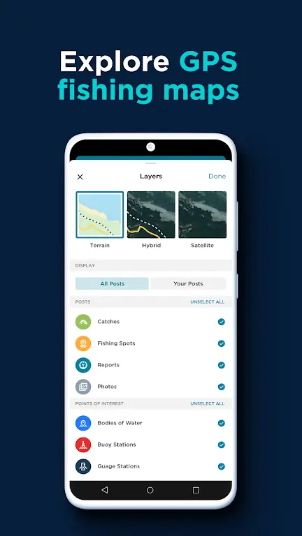
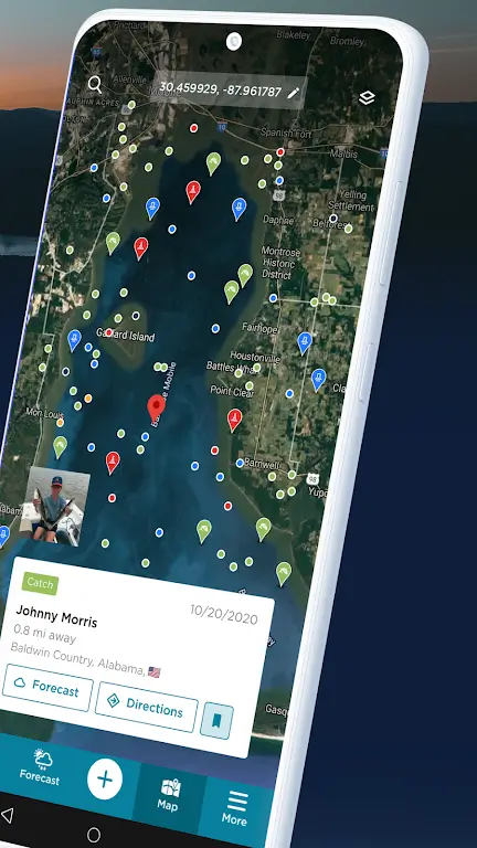
EXPLORE THE AQUATIC WORLD WITH GPS FISHING MAPS: The app’s GPS fishing maps take exploration to a whole new level. The maps showcase fishing spots, marine buoys, and river gauges, with detailed catch data and fish species info. You can save GPS coordinates as waypoints, spicing them up with photos, videos, and descriptions. This feature lets you search millions of water bodies, from vast oceans and lakes to rivers and tiny ponds.
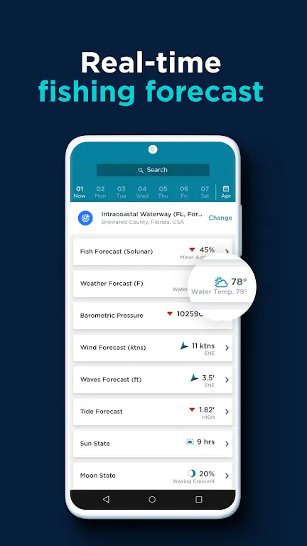
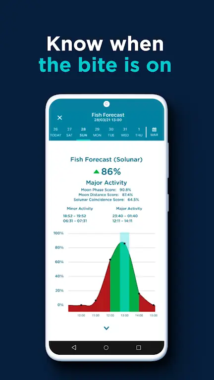
GET AHEAD WITH THE FISHING FORECAST: The FishAngler fishing forecast is your reliable friend who knows when the fish will bite. It offers real-time, seven-day marine weather forecasts with essential information such as wind, wave, tide, and water temperatures. With NOAA Marine Buoy, USGS Inland station monitoring and fishing tide charts, you’ll always be ahead of the game. The Solunar fishing forecast reveals when the fish are the most active and ready for a snack – your bait!
YOUR PERSONALIZED FISHING LOGBOOK: FishAngler is your digital fishing logbook, allowing you to track and organize your fishing trips meticulously and catches with over 45 attributes. The app auto-logs your catch with details like date, time, weather conditions, water temperatures, sun & moon phases, and more. Plus, it keeps track of the most commonly used bait, lures, flies, and hooks. With FishAngler, privacy is in your hands; you can share your catches or maintain secrecy like a true master angler!
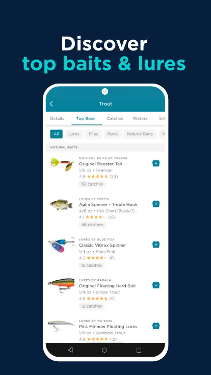
GEAR UP WITH TOP BAITS & LURES: The app brings an end to fishing guesswork with aggregated catches and top gear recommendations. Find the best baits and lures to catch specific fish species near you. Moreover, it offers ratings and reviews on over 100k pieces of gear, giving you an upper hand in selecting the most effective fishing equipment.
Interactive fishing maps with millions of confirmed catch locations. Filter by species and see what type of fish are being caught near you.
Get local points of interest including access points, boat ramps, underwater structures, artificial reefs and more.
Advanced map layers including nautical charts and ocean contours to help you navigate and pinpoint your next fishing spot.
Access HD depth maps to get a detailed view of underwater structures. Visualize drop-offs, shallows and prime fish habitat.
Identify the best times to fish with local and hourly forecast conditions. Know when the fish are most active and ready to bite.
7-day weather forecasts allows you to see patterns day in advance so you can pick the best day and time to go fishing.
Marine forecasts with tide charts (low and high tides), wind and wave reports. Get access to sun & moon phases, barometric pressure and water flow rates.
Keep track of all of your fishing trips and catches. Capture information such as fish species, date & time, size, location, gear used and weather conditions.
Improve your fishing with personal stats. Log gear and spot patterns in your fishing by seeing which baits are most effective in specific conditions.
You have complete control over your privacy settings. You can choose to share your catch information or keep it private!
Stop the guesswork and see aggregated catch information with top gear recommendations
See the best baits & lures used to catch specific fish species near you
Get ratings & reviews on more than 100k pieces of gear
Connect with millions of anglers and find new fishing friends on the FishAngler platform
Join conversations, exchange tips & tricks, join fishing groups and learn new fishing techniques
Find anglers based on fishing technique or interests (fly fishing, bass, kayak, saltwater etc.)
How do I find fishing spots around me?
Select the “Map” icon on the navigation bar at the bottom of the app screen. Place your finger on the map and drag to change location on the map. Double tap or press the “+” and “-” icons at the bottom right-hand corner of the map to zoom in and out. You can also “pinch and zoom” in and out by placing two fingers on the screen close together and dragging them apart to hone closer in on a region, or placing two fingers on the screen farther apart and pulling them together to make the map region larger.You can search for bodies of water nearby at the top of the screen, or tap catches, photo and fishing spot icons to see where other users are catching fish.
What if some fishing locations are not on the map?
You can report missing bodies of water. To do so, tap the “More” icon in the bottom right-hand corner of the app screen, then tap “Bodies of Water near me”. Then, select the “+” symbol in the upper right-hand corner. Select the map screen and center the crosshair icon on the missing body of water then tap “Done”.
How do I find accessible fishing locations?
A great way to access bodies of water is to select the “Map” icon on the navigation menu and place your cursor in the search bar at the top of the screen. Bodies of water will populate the “Nearby” section under Current Location, Favorites and the Recent section.
Select an body of water, and an information card will pop up at the bottom of the map screen. In the lower right-hand corner of the card you will see icons for weather and directions. Selecting the directions icon will prompt you to open the body of water address in one of your map apps, or to copy the address or coordinates to your clipboard. Select an option and you’ll be on your way!
How do I Report a Missing Body Of Water?
Select the “More” icon in the bottom right-hand corner of your FishAngler app screen. Then scroll down and tap “Bodies of Water near me” under the Discover section. Press the the “+” symbol in the upper right-hand corner of the screen. Tap the map screen and center your the crosshairs on the missing body of water and press “Done”.Next add the body of water name, a possible alternate name, and any notes you have for the FishAngler Team regarding the body of water.The FishAngler Team will reply to your body of water report as soon as possible.
What do Navionics map symbols mean?
Navionics maps use contour lines to indicate depth in meters, with numbers showing specific depths. Lower numbers represent shallower water, while higher numbers indicate deeper areas. Closely spaced lines suggest steep terrain, while wider spacing indicates gentle slopes. These contours also reveal underwater features like seamounts and trenches. Additionally, bathymetric maps may use colors to depict depth zones: warm colors for shallow areas and cool colors for deeper zones, each supporting different marine life.
FishAngler – Fishing App – an extremely attractive offer for fans of fishing. According to the tradition of such software, the presented version represents a whole range of opportunities and tools for productive pastime with gear. An interactive map that is constantly evolving, changing and replenishing, forecasts, tips, communication of like-minded people, the ability to create and edit yourself, keep a log of events, and so on. There is, in fact, encyclopedic material. For a better understanding of what it is desirable to hook on the hook. So it’s not surprising that the program has become a popular solution.
Size:39.5MB Version:4.1.1.183
Requirements:Android Votes:482
Fishing is an activity that truly tests one's patience, yet it also brings a deep sense of relaxation and joy. As you sit quietly by the water, watching the gentle ripples and feeling the anticipation build, every moment becomes part of the experience. Then, after a long wait, the thrilling tug on your line signals the catch-your hands tighten on the rod, your heart races, and with a steady pull, you finally reel it in. Whether it's a small fish or a big one, the satisfaction of a successful catch brings an undeniable sense of accomplishment. So, cast your line, enjoy the tranquility, and when the moment comes, don't forget to smile and celebrate your success!
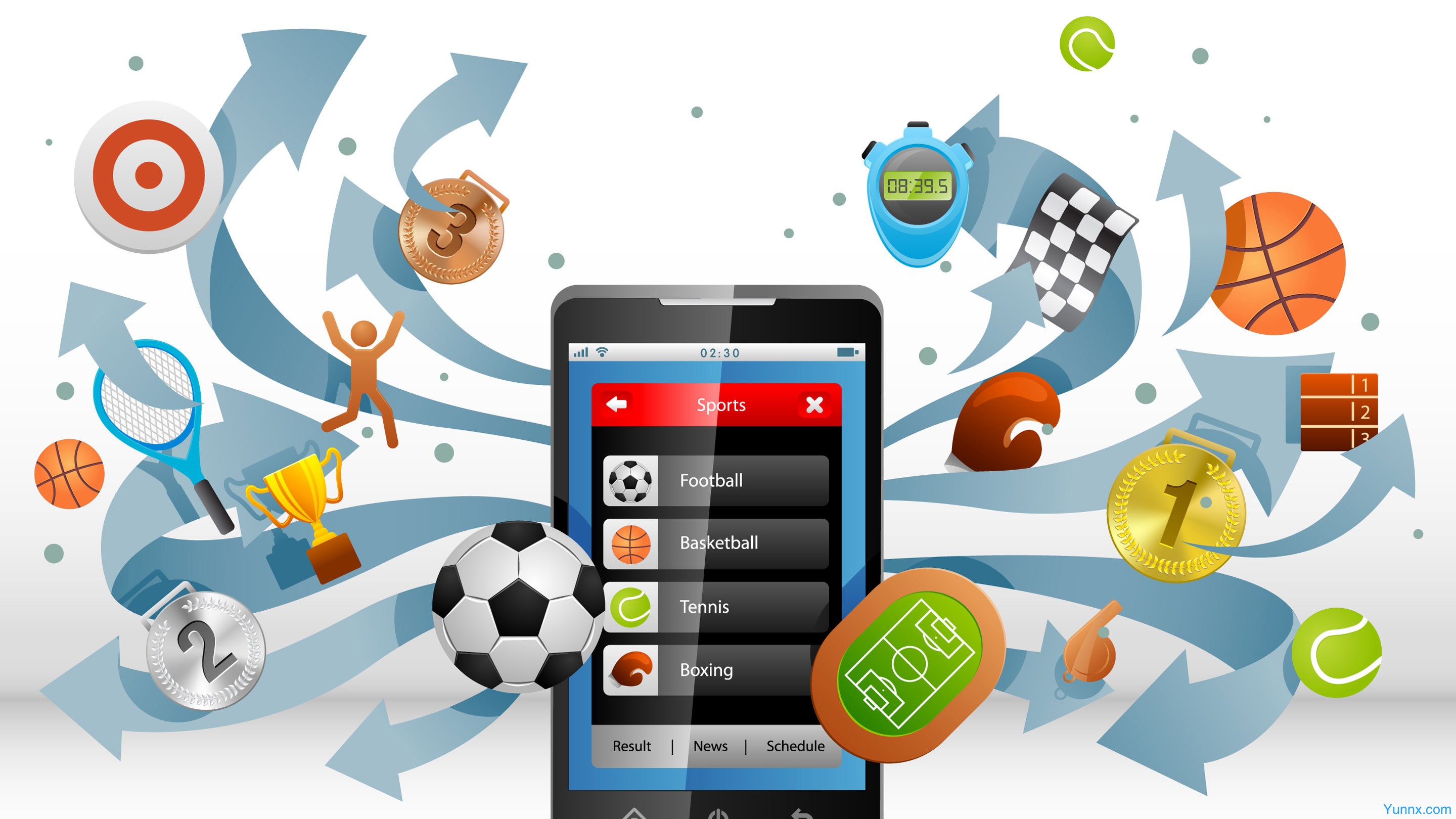
Sport Apps is an all - in - one platform that brings together a diverse range of sports - related applications, designed to meet the needs of every sports enthusiast. Whether you're a professional athlete, a fitness fanatic, or someone who simply enjoys staying active, this aggregation page is your go - to destination.
Life lies in exercise, which is an important way to maintain a healthy physique. Proper exercise can control body shape and weight, as well as increase the body's metabolic rate and burn body fat. Long term exercise can reduce the risk of various chronic diseases. So, what are the sports and health apps to download and install? There are many sports and health apps now that help people exercise together and record their exercise time. Next, the editor recommends several sports and health apps for everyone.
About us | Contact us | Privacy policy| DMCA
Copyright © 2026 Xiaohei All rights reserved.