OsmAnd+ is a navigation app that will be your best companion on your journeys. With this app, you no longer have to worry about getting lost in new lands. Whether you're on a bike, in a car, or simply walking, OsmAnd+ will guide you every step of the way. This app allows you to view and use offline maps, making it convenient to use even when you're not connected to the internet. Plus, it also offers voice-guided navigation to ensure you stay on the right track. It is the perfect app for those who want to explore and conquer new roads with ease.
Added a full-screen gallery viewer for Wikimedia images.
Introduced a new plugin "Vehicle Metrics" to monitor vehicle performance using the OBD-II protocol.
Added the ability to assign activities to tracks and filter them accordingly.
Implemented new quick actions for trip recording and touchscreen lock.
Introduced customizable map button appearance and a precise grid.
Added a context menu and a "Reset average speed" action to widgets.
Added new route layer "Dirt Bike trails".
Fixed "Auto-record track during navigation".
Fixed issue with fliped coordinates in RTL.
Fixed missed sensor data for currently recording track.
Added information about surrounding areas for the selected point.
Added quick action to control visibility of OSM Edits.
Separated visibility parameters for Terrain colorization options.
Added a tappable icon to display access or other road or path attributes.
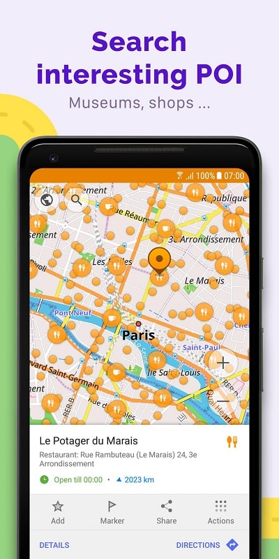
Options for locations to be shown on the map, including tourist destinations, restaurants, hospitals, and more.
You may search for locations by entering an address, name, coordinates, or category.
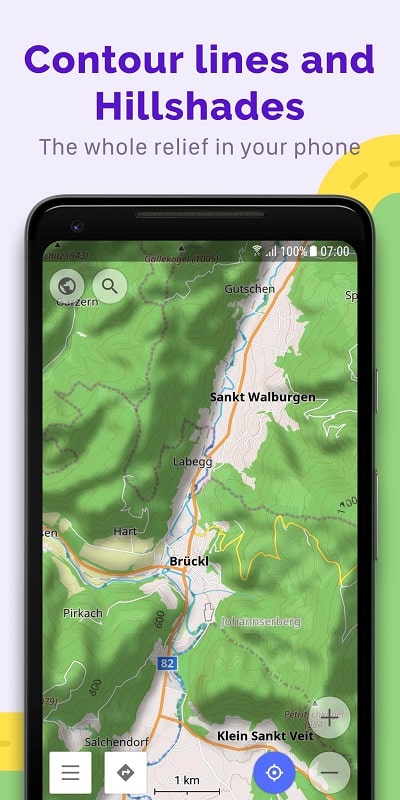
A variety of map formats are designed to facilitate a selection of activities, including touring view, nautical map, winter and ski, topographic, desert, off-road, and others.
Shading relief and contour lines that may be filled in.
The capacity to superimpose maps derived from several sources on top of one another.
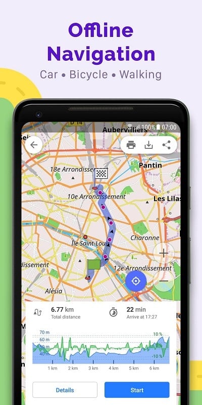
Making plans to go to a location that does not have access to the internet.
Individually tunable navigation profiles for a wide variety of conveyances, including automobiles, motorbikes, bicycles, 4x4s, pedestrians, boats, and other. modes of public and private transportation, among others.
Alter the created route so that it does not take particular highways or road surfaces into consideration.
Information widgets about the route that may be personalized, including distance, speed, remaining travel time, distance to the next turn, and more.
Mapping out a path one location at a time with the assistance of one or more navigation profiles.
Recording routes using GPX tracks.
Managing GPX tracks, including displaying your own or imported GPX tracks on the map and navigating between those tracks.
Graphical information on the course, including distances traveled, ascents, and descents.
OpenStreetMap users now have the ability to publish their GPX tracks.
Take advantage of offline maps: Save map data to your device and use the app offline to avoid relying on an internet connection. This way, you can navigate even in remote areas or places with poor network coverage.
Utilize voice search: Instead of manually typing locations, use the voice search feature to quickly and conveniently search for places. This saves time and ensures accurate results.
Familiarize yourself with the map features: Explore and get comfortable with the various features of OsmAnd +, such as selecting locations by local names and landmarks, to make the most out of the app's capabilities.
Full of important functions for map application.
Full display of popular places (restaurants, hotels, gas stations, museums).
Support voice guidance, and public transport navigation.
Update data daily.
Independent, unrecognized mapping system.
The update is still incomplete, and needs a lot of improvement.
OsmAnd+ is a highly reliable and user-friendly navigation app that provides offline and online map access, voice guidance, route creation and management, and efficient search functionality. With its numerous features and helpful playing tips, OsmAnd+ ensures that you can navigate with ease, whether you're in a car, on a bike, or on foot. Whether you prefer to drive, cycle, or walk, OsmAnd+ provides user-friendly navigation with both map and voice guidance. It allows for offline and online use, ensuring that users can rely on the app no matter their location or network connectivity. With its accurate search function and comprehensive map features, it is a valuable tool in helping users find their destinations quickly and stay on the right track.
Size:335.49MB Version:4.6.6
Requirements:Android Votes:592
Feeling like you have endless free time or stuck in a boredom rut? Dive into these captivating games, and before you know it, you'll be wondering - "How did the hours fly by so fast?" Whether you're looking for deep strategy, immersive storytelling, or quick, addictive gameplay, these picks will keep you hooked. From intense card battles to mind-bending puzzles, each game offers a unique way to make time disappear. So grab your controller, shuffle your deck, or boot up your favorite platform - your next "just one more round" obsession awaits!
Welcome to the ultimate hub for simulation management gaming enthusiasts! This centralized platform is designed to meet all your needs as a fan of immersive virtual world-building and strategic decision-making experiences. Commonly known as SM games, simulation management titles deliver a uniquely engaging form of interactive entertainment. These games place you in control of complex systems, letting you assume roles ranging from visionary city planners to ambitious entrepreneurs. Whether constructing a thriving metropolis, optimizing a corporate empire, or cultivating a prosperous agricultural business, SM games masterfully combine strategic planning, creative problem-solving, and impactful decision-making. Their blend of challenge and reward continues to attract players seeking deep, satisfying gameplay experiences.
Nowadays, with the popularity of smartphones, navigation software has become an essential tool for people's travel. Among numerous Android mobile navigation software, some are highly regarded for providing users with convenient navigation services. These software not only have accurate positioning functions, but also can update road condition information in real time, providing users with the best driving route. At the same time, they also offer multiple travel options such as walking, public transportation, self driving, etc., and can intelligently plan routes based on user needs. In addition, these navigation software also have voice navigation function, making it convenient for users to obtain navigation guidance at any time while driving. In short, Android mobile navigation software can provide users with comprehensive route planning services, making travel more convenient and safe.
About us | Contact us | Privacy policy| DMCA
Copyright © 2026 Xiaohei All rights reserved.